
- Navigation:
- Back to the Corpus index page
- RSS
Leny Parish Church
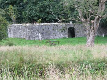
Leny, burial enclosure, from south
- Dedication: unknown
- Diocese of Dunblane
- County of Perthshire
- Stirling Council
- NN 6213 0760?
Summary description
The most likely site for the parish church of Leny is a burial enclosure in a graveyard to the south-west of Callander, at the confluence of the Eas Gobhain, which flows from Loch Venachar, and the River Teith.
Historical outline
Dedication: unknown
The earliest surviving reference to the church of Leny dates from 1238 when, it formed part of the settlement of a long-running dispute between Walter Comyn, earl of Menteith, and Clement, bishop of Dunblane, over rights to revenues from parish churches in Menteith.(1) By the terms of the settlement, Earl Walter was permitted to found an Augustinian priory at Inchmahome and the church of Leny was appropriated to it from the date of its foundation and was still recorded as annexed to the priory in 1561/2.(2) The settlement also prohibited the bishop from instituting vicars perpetual in the church and allowed Inchmahome to have the cure served by a chaplain. In 1507, however, one Cuthbert Leny, vicar of Leny, is recorded,(3) but it is not clear if he was a vicar portionary or perpetual.
Notes
Architectural description
The site of Leny Parish Church is no longer known with complete certainty. The most likely location is a graveyard to the south-west of Callander, on a gravel ridge at the confluence of Eas Gobhain with the River Teith, the church site being on the spine of the ridge above the flood-plain. According to the Statistical Account, published in 1794, Callander was initially divided into two parishes. However, in the course of a flood ‘more than a century ago’, the church of Leny had been separated from its parish when the ‘northern branch of the river’ changed course, while the bridge leading to the chapel over ‘the southern branch’ was swept away. Following this a single new church to serve both parishes was built at Callander. The description of the relationship of the church with the branches of the rivers accords well with a site at NN 6213 0760, a site that is known locally as Little Leny.
The principal focus of the graveyard there is an oriented rectangular burial enclosure with dimensions of 19.25 metres from east to west and 7.7 metres from south to north, and with walls of 65 centimetres in thickness. This enclosure is entered by a round-arched rebated doorway with narrowly chamfered arrises near the centre of the south wall. Above that doorway is a gablet, decorated with volute crockets and a thistle finial, which is inscribed ‘the Buchanan Chapel 1214’ in reference to the family whose members are buried within it. The style of lettering on that gablet is similar to that on three tablets built into the internal walls of the enclosure which indicate the burial layers, two of which are dated 1724, and it is likely that the gablet is of the same date.
The wall-heads of the enclosure are coped with rough stones, but at the angles are worked stones, three of which are clearly the caps or a base from the nook shafts of what is most likely to have been a doorway of late twelfth- or early thirteenth-century date. That at the south-west corner is an inverted base of water-holding form. At the south-east corner is a capital of unique form, on the bell of which is a figure with outstretched arms, presumably intended to represent the crucified Christ; the head of the figure acts as the leading angle volute, while the hands appear to grasp crockets at the two other exposed angles. The abacus is of the square form to be expected at the turn of the twelfth and thirteenth centuries. At the north-east corner of the wall head is a heavily weathered capital of similar overall form, but with its bell apparently having been decorated with more orthodox foliage forms.
The re-use of medieval fragments on such an isolated site suggests that this was indeed the location of the medieval church, and that it must have been a church of some architectural quality. Beyond that, however, the orientation and dimensions of the burial enclosure raise the possibility that the enclosure is on the footprint of its medieval predecessor. A further factor that must be taken into account is that to the east of the enclosure, and extending for a distance of about 7 metres, is what appears to be a slightly raised platform. While the case for this must be argued with less conviction, it should be considered as a possibility that the burial enclosure occupied no more than the site of the nave of the medieval church, and that the chancel of a church that originally extended to about 26.25 metres had been abandoned.
Bibliography
Cowan, I.B., 1967, The parishes of medieval Scotland, (Scottish Record Society), Edinburgh, 130.
Fraser, W., 1880, The Red Book of Menteith, Edinburgh, ii, 326.
Kirk, J., 1995, The books of assumption of the thirds of benefices, (British Academy) Oxford, 545, 548, 549.
New Statistical Account of Scotland, 1845, Edinburgh and London, x, 1105.
Royal Commission on the Ancient and Historical Monuments of Scotland, Canmore database.
Statistical Account of Scotland, 1791-9, ed. J. Sinclair, Edinburgh, xi (1794), 575.
Map
Images
Click on any thumbnail to open the image gallery and slideshow.
1. Leny, burial enclosure, from south
2. Leny burial enclosure, inscription 3
3. Leny burial enclosure, inscription 2
4. Leny burial enclosure, inscription 1
5. Leny burial enclosure, gablet over entrance
6. Leny burial enclosure, nookshaft base at south west corner, b
7. Leny burial enclosure, nookshaft base at south west corner, a
8. Leny burial enclosure, nookshaft cap at north east corner
9. Leny burial enclosure,burial enclosure nookshaft base at south east corner
10. Leny, burial enclosure and churchyard, from west
11. Leny, burial enclosure and platform to east
12. Leny, burial enclosure, from north west