
- Navigation:
- Back to the Corpus index page
- RSS
Saline Parish Church
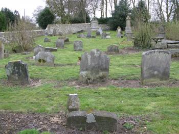
Saline Old Churchyard, looking east
- Dedication: unknown
- Diocese of Dunkeld
- Deanery of Fife and Strathearn
- County of Fife
- Stirling Council
- c. NT 023 924 ?
Summary description
The medieval parish church is assumed to have been located in a graveyard on the south side of Bridge Street, to the north-east of the present parish church, though nothing is now firmly identifiable of the medieval building.
Historical outline
Dedication: unknown
Alexander Myln’s statement in his Vitae Dunkeldensis Ecclesiae Episcoporum that the church of Saline was one of three establishments annexed by Bishop Geoffrey (1236-49) to the common fund of the canons of Dunkeld appears to be corroborated by the non-appearance of the church in Bagimond’s Roll in the 1270s.(1) It is likely that the cure was served by a vicar pensionary from the time of the original annexation, but this is not confirmed until November 1430 when Alexander of Kinglassie supplicated for fresh provision to the vicarage, which was valued at only £8 per annum.(2) Alexander’s possession of the vicarage was disputed by one William Rollok or Rollo, who may have been using the fruits of the benefice to fund him through his university studies at Paris or who had secured provision on completion of his studies, but who had not yet in December 1431 been promoted to priest’s orders as was required of him.(3) Rollo appears to have been successful in securing possession and in 1435 was described as ‘perpetual vicar’ of Saline.(4) In that year he exchanged Saline for the vicarage of Tibbermore with sir Patrick Furde, who in 1450/1 was still incumbent.(5) It is clear, however, that the ‘perpetual’ vicarage was only pensionary. The parsonage and vicarage remained annexed to the common fund of Dunkeld at the Reformation.(6)
Notes
Architectural description
The existing church was built to the designs of William Stark in 1808-10, its predecessor having been described in the Statistical Account of 1794 as ‘in a bad state…[that]…will scarcely admit of repairs’. The absence of any burials around the church immediately suggests that it was not built on the site of the previous building, and the most likely location for that church is a graveyard on the south side of Bridge Street. That likelihood is supported by the recorded existence of a manse a short way to its north on the second edition of the Ordnance Survey. Further support may perhaps be derived from the existence to the west of the churchyard of a secularised Free Church, which was built to the designs of Lewis Mercer in 1844 following the Disruption of 1843.
Although the precise position of the church appears to be unknown, close to the east end of the churchyard is a large eighteenth-century aedicular monument that is built against masonry that appears to be the truncated portion of a wall. It should be seen as a possibility that this monument had originally been located within the chancel of the previous church, and that a portion of the east wall against which it had been set was retained when the rest of the church was demolished, a process that is known to have happened elsewhere. Against that possibility, however, is the fact that the graveyard slopes relatively steeply towards the west, and would have presented a challenging site for a church building.
Bibliography
Calendar of Scottish Supplications to Rome 1428-32, 1970, ed. A.I. Dunlop; and I.B. Cowan, (Scottish History Society) Edinburgh, 150, 197.
Calendar of Scottish Supplications to Rome 1433-47, 1983, ed. A.I. Dunlop and D MacLauchlan, Glasgow, no 178.
Cowan, I.B., 1967, The parishes of medieval Scotland, (Scottish Record Society), Edinburgh, 179.
Gifford, J., 1988, The Buildings of Scotland, Fife, London, 408-9.
Kirk, J., 1995, The books of assumption of the thirds of benefices, (British Academy) Oxford, 300, 335-6.
Registrum Magni Sigilli Regum Scottorum, 1882, Edinburgh, ii (1424-1513), no 496.
Statistical Account of Scotland, 1791-9, ed. J. Sinclair, Edinburgh, x (1794), 311.
Vitae Dunkeldensis Ecclesiae Episcoporum…Ad Annum Mdxv, 1823, ed. T Thomson, (Bannatyne Club), Edinburgh, 10.
Map
Images
Click on any thumbnail to open the image gallery and slideshow.
1. Saline Old Churchyard, looking east
2. Saline, Free Church
3. Saline New Church, 2
4. Saline New Church, 1
5. Saline Old Churchyard, burial enclosure
6. Saline Old Churchyard, east end, wall monument
7. Saline Old Churchyard, looking west